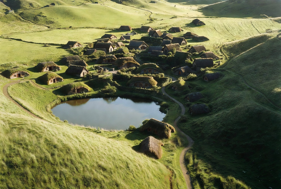
What’s on the Ground
The set is roughly twelve acres laid into a curving valley. Below is every fixed structure — what it is, what was filmed there, and where to find it on the ground.
 12 acres · 44 hobbit holes
Ten fixed points
A walk through the village runs roughly 01 → 10 — pond first, hill last. Each point on the map is a structure, a tree, or a piece of land that earned its place on screen.
-
Bag End
The most photographed front door in cinema. Sits at the top of the hill, framed by an artificial oak, an apple tree, and a hand-built stone path. Frodo and Bilbo’s home — and the only hobbit hole built at full interior scale on this site.
-
The Party Tree
The single Monterey pine that started everything. Spotted from the air in 1998. Stands beside the field where Bilbo’s birthday party was filmed. Older than the set itself.
-
The Party Field
Open meadow at the foot of the hill. The fireworks scene was filmed here. On a still day it’s the quietest part of the valley.
-
The Green Dragon Inn
Built as a façade in 1999, rebuilt as a real working tavern in 2011. Stone, timber, thatched roof. Serves an ale brewed for the location.
-
The Mill & Bridge
The double-arch stone bridge crosses a small stream beside the watermill. Both were rebuilt in permanent materials for the second trilogy.
-
Bagshot Row
The cluster of hobbit holes immediately below Bag End — including Sam Gamgee’s. The chimneys here are the most visible from the lake.
-
The Vegetable Gardens
Real, working gardens. Planted ahead of every shoot. Today still tended weekly so the village reads as lived-in.
-
The 44 Hobbit Holes
Set into the south-facing slope across the village. Built at varying scales — some full-size, some forced-perspective — to make hobbits look small beside taller characters.
-
The Lake
The still pond below the Party Tree. Reflects the village on calm mornings. Originally just a stock-water pond on the Alexander farm.
-
The Hill
The land itself. A natural rise on the farm — the reason the location works at all. Bag End sits at its crown; the village wraps its southern face.
Where it sits.
The set is at 501 Buckland Road, Hinuera, Matamata 3472 — about 80 km southeast of Hamilton and roughly two hours by car from Auckland. The closest town is Matamata. The land is in the Waikato region, in the rolling country between the Kaimai Range and the Waikato River.
This site does not sell tours. The official operator runs guided visits daily; we have no involvement with bookings.